“Go sailing now my friend,
it is later than you think”


“Go sailing now my friend,
it is later than you think”
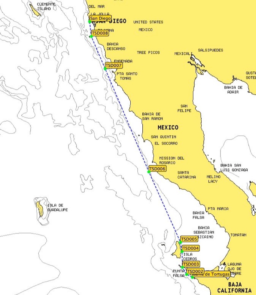
Bahia de Tortugas to San Diego is 330 miles. A couple days passage.
Most of this part of the coast, we will be moving along as quickly as possible and only stopping for fuel and or to wait for weather to pass. This is a spectacular coast for its stark beauty. The barren jagged land and the teaming ocean waters.
On the Way. . .
Cedros Harbor
Large harbor protected by breakwall. Anchoring inside inner harbor or getting a side tie may be allowed if you already cleared into Mexico such as at Ensenada. Good protection from all wind/sea directions. Permission to stay at the discretion of the local officials. There is room for many boats.
Cedros North Cove
Anchor in 45' over sand on narrow shelf. Two deep arroyos further S also provide anchorage, but the W and NW winds can funnel down the arroyos making them uncomfortable.
We arrived at Cedros island mid-afternoon today and dropped the anchor on the N end of the island. One guide book described this as a "memorable" location, but to me it was absolutely fantastic.
First off, Cedros is a big mountainous island...about 20 miles long and a few miles wide...and is relatively uninhabited. The island rises to over 4,000 feet and is quite dry. The mountains are generally brownish in color, ranging from a burnt umber to a light moss green, and are covered by widely scattered scrub plants. The only trees that we saw were at the N end where there's a very small fishing village. The only other village is on the SE end, but we never saw that due to fog.
Punta Baja - Isla San Geronimo
Isla San Geronimo
Open roadstead usable in light NW winds. But, according to Charlie's Charts, a quite comfortable anchorage can be found on the east end of the island, off the village, in 26 ft. Wide open and rolls. Watch out for fishing floats. On the positive side, trade for fish.
Punta Baja
Wide crescent between Punta Baja and Punta San Antonio. Give the tip of Punta Baja a half mile berth. Anchor in sand about 1/4 mile off shore in 15' of water.
Can hold 20 boats in a NW blow. In S wind this is a surf zone.
Isla San Martin - Cabo San Quintin
San Quintin
5 mile wide crescent shaped bay SE of Cabo San Quintin. Anchor on the E edge of Cabo San Quintin and S of the breakers in 18' to 25' of water and in sand/shells. From here you can watch the pangueris navigate through the breakers as they enter the estuary.
Isla San Martin
Ok if you only overnight in fair weather. I wouldn't want to be caught here in any kind of a blow. Slightly protected from the South in a lagoon formed by a finger of land coming off the East side of San Martin. Use caution in the lagoon it gets shallow quickly. The island was once volcanic so it has a cut off cinder cone top. Come around the North side of the Island. There is a small fishing camp on the East side. You'll see small breakers on the South side of the protective finger of land.
Ensenada
Is a coastal city, the third-largest in Baja California. Lying 78 miles south of San Diego on the Baja California Peninsula, it is locally referred to as La Cenicienta del Pacífico, "The Cinderella of the Pacific".
One of the first settlements founded in the Californias, Ensenada has emerged as a cruise ship destination, aerospace center, and heart of a wine country regarded as one of the best in the Americas alongside Napa Valley. It is said that the first Vitis vinifera made it to the region's San Ignacio Mission in 1703, when Jesuit Padre Juan de Ugarte planted the first vineyards there.
Situated on the coastline of Bahía de Todos Santos — an inlet of the Pacific Ocean on the peninsula's Gold Coast — the Port of Ensenada is an important commercial, fishing, and tourist port. Residents often refer to themselves as "porteños" (port-dwellers), in reference to the historic harbor.
Ensenada is backed by small mountain ranges. Proximity to the Pacific and a warm Mediterranean latitude create mild year-round weather. The rainy season during the winter is short and the area is prone to prolonged droughts, which can threaten its grape harvests.
San Diego
Is the second-largest city in California. The city is located immediately adjacent to the Mexican border. The birthplace of California, San Diego is known for its mild year-round climate, natural deep-water harbor and extensive beaches. San Diego was the first site visited by Europeans on what is now the West Coast of the United States. Upon landing in San Diego Bay in 1542, Juan Cabrillo claimed the entire area for Spain, forming the basis for the settlement of Alta California 200 years later. The Presidio and Mission of San Diego, founded in 1769, were the first European settlement in what is now California. In 1821, San Diego became part of newly independent Mexico, and in 1850, became part of the United States following the Mexican-American War and the admission of California to the union.
Tamarindo Surf Forecast and Surf Reports (Guanacaste, Costa Rica)